Running in Shanghai: Best Running Routes & Clubs
Compare seven Shanghai running routes with maps, GPX downloads and metro access, from the Century Park loop to the Bund and Suzhou Creek.
For repeat laps, head to Century Park in Pudong. For waterfront views, choose a stretch of the Huangpu or Suzhou Creek. The streets around Wukang Road suit an easier sightseeing run with stops at crossings.
In summer, head out early to avoid the worst of the heat. Check the air quality before you leave, and join a local club session if you want company.
Best Running Routes in Shanghai
| Route | Distance | Best for |
|---|---|---|
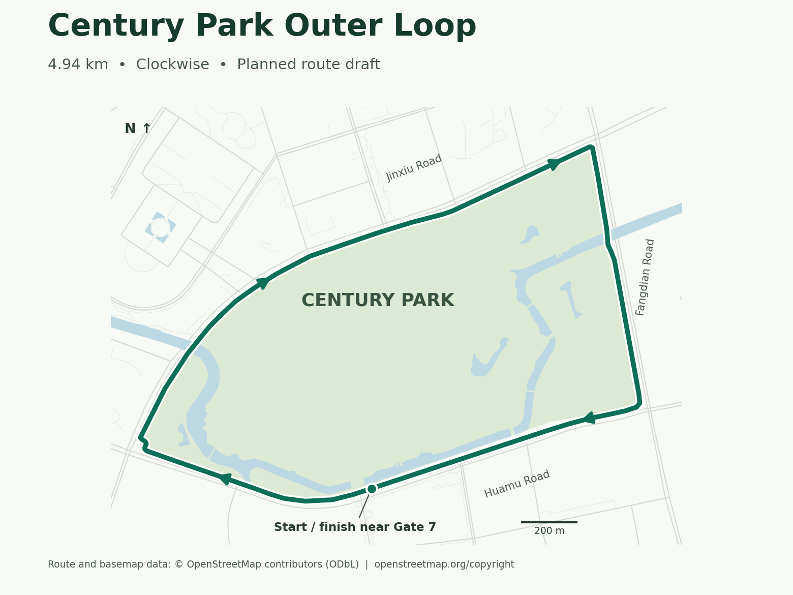
| Century Park Outer Loop | 4.94km Clockwise loop | Tempo runs and repeat laps |
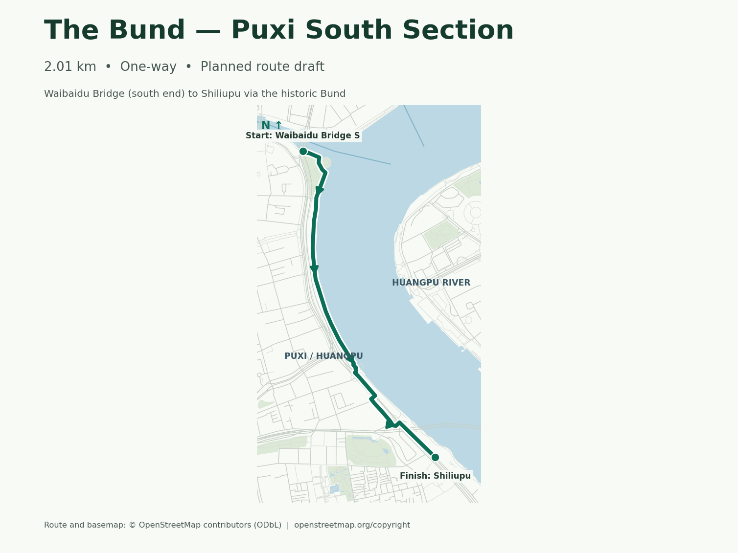
| South Bund | 2.01km Point to point | A short skyline run |
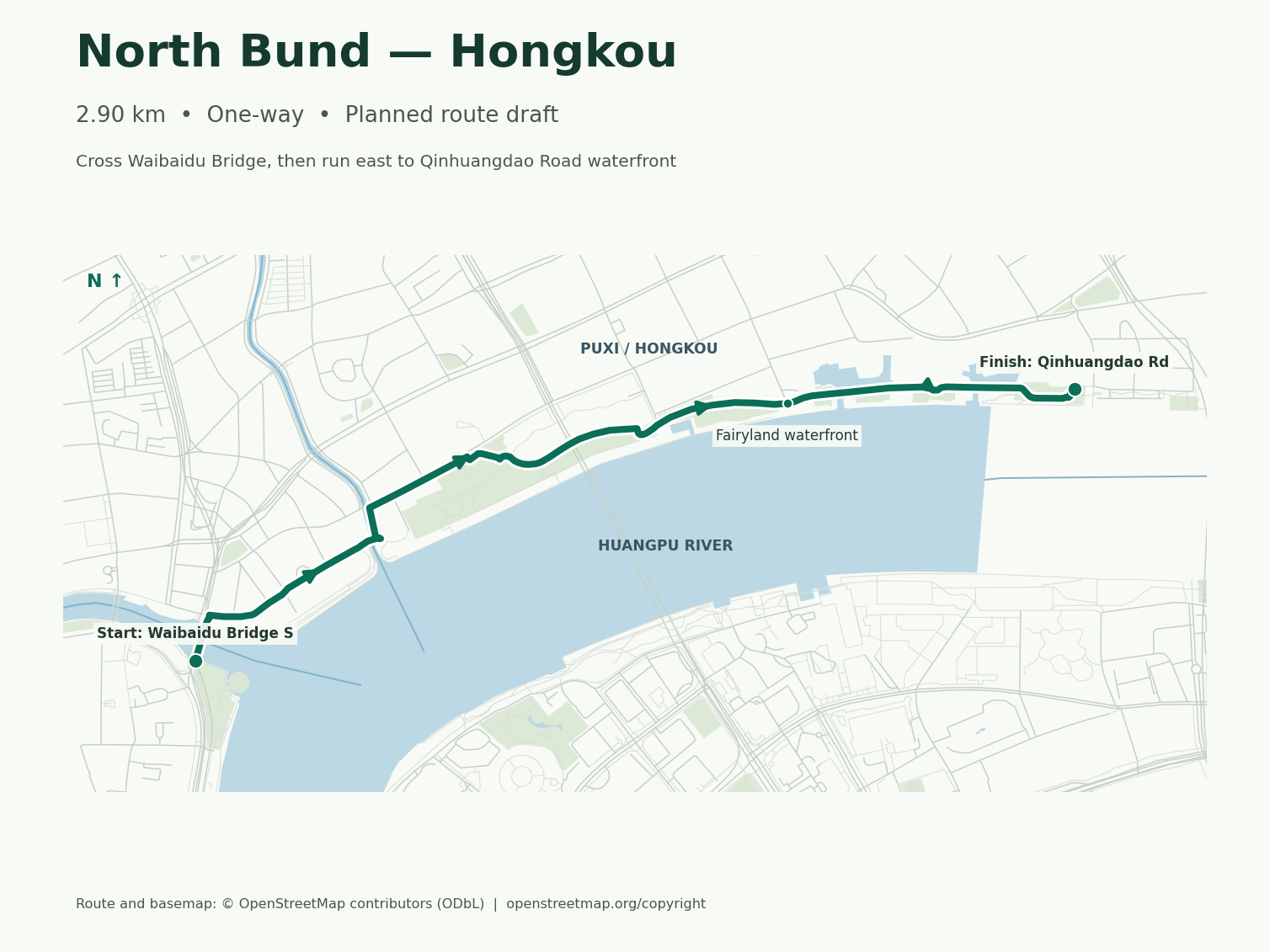
| North Bund | 2.90km Point to point | Waterfront views from Hongkou |
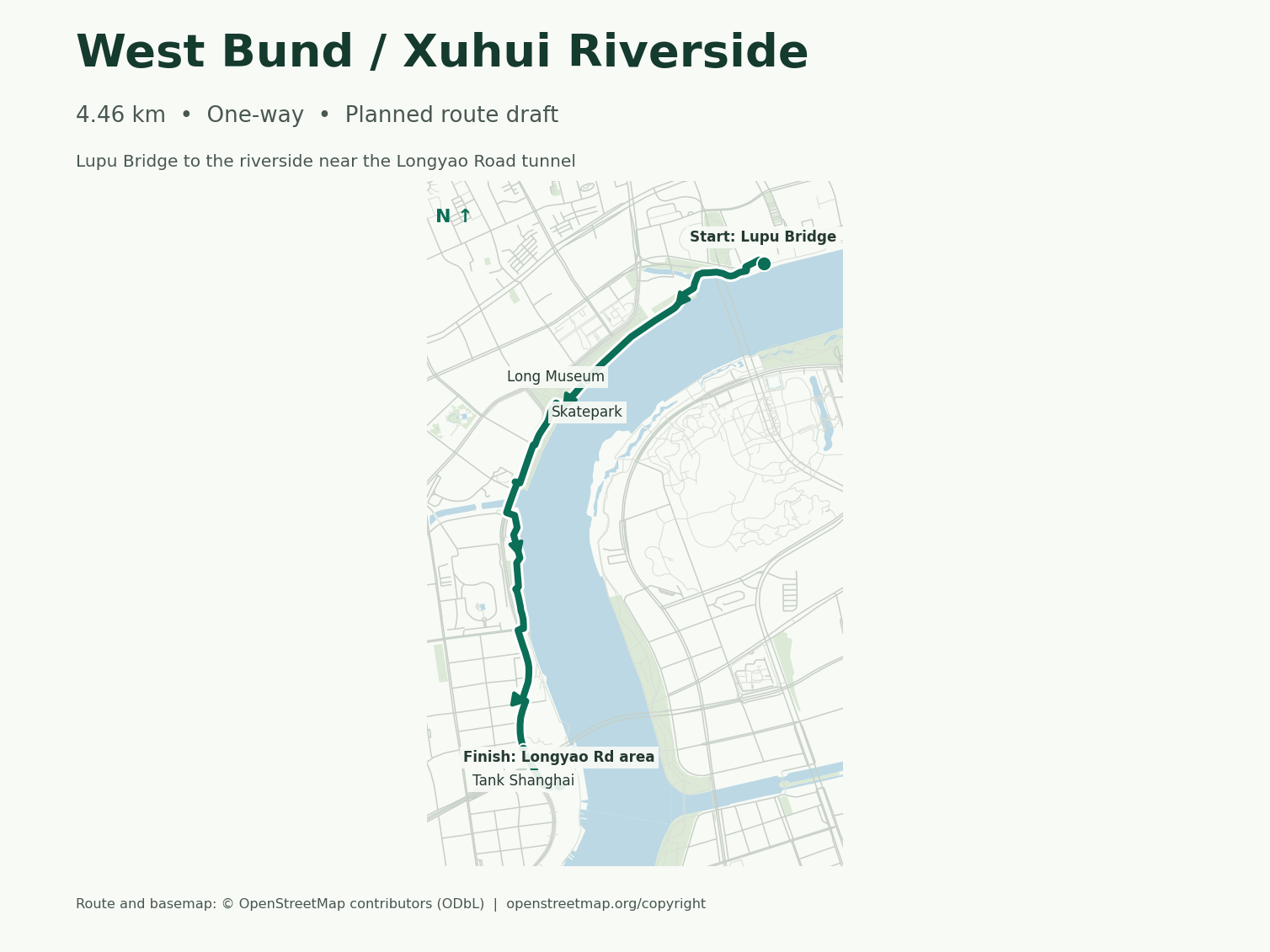
| Xuhui Riverside | 4.46km Point to point | A steady riverside run |
| Half-Marathon Suhe Park | 5.47km Out and back | A riverside run with an easy return |
| French Concession Streets | 5.66km Point to point | A street run through tree-lined blocks |
| Suzhou Creek Greenway | 8.14km Point to point | A longer run with a Bund extension |
Distances are measured from the downloadable tracks. Looking for track intervals? See Luwan Stadium.
Century Park Outer Loop
Start and finish near Gate 7
- Getting there
- Take Metro Line 2 to Century Park, then cross the street from Exit 4 toward Gate 7.
- Underfoot
- Follow the rubberized path around the outside of the park. The loop returns to your starting point.
Before you runWater, toilets, bag storage and timing
- Water, toilets and bags
- The Gate 1 visitor center lists bag storage. Runner reports point to lockers and a restroom outside Gate 7, plus face-scan lockers by Gate 3. Check the posted hours and prices before leaving a bag.
- When to go
- Weekday mornings are a good time for steady laps. Runners report using the outer loop after dark, though lighting has not been checked along every stretch. Drinking water is reported along the loop, but the nearest tap to Gate 7 is unconfirmed.
South Bund
Waibaidu Bridge, south end → Shiliupu
- Getting there
- Start at the south end of Waibaidu Bridge near Huangpu Park. Yuyuan Garden is a return metro option from Shiliupu.
- Underfoot
- Run south along the Huangpu promenade. Expect hard paving and possible steps or short ramps at promenade access points.
From Shiliupu, continue south toward Lupu Bridge to connect with Xuhui Riverside.
Before you runWater, toilets, bag storage and timing
- Water, toilets and bags
- Use the Huangpu Park toilets before starting. Bring water and plan to carry your bag.
- When to go
- A weekday morning gives you more room on the promenade. Foot-level lighting at ramps and the Shiliupu connection has not been checked.
North Bund
Waibaidu Bridge, south end → Qinhuangdao Road waterfront
- Getting there
- Cross Waibaidu Bridge from its south end. For the return, head toward Yangshupu Road station on Line 4.
- Underfoot
- The bridge has a wooden pedestrian surface. The route then follows paved waterfront paths with shared-use segments and possible short ramps or steps near Hongkou Port.
Before you runWater, toilets, bag storage and timing
- Water, toilets and bags
- The runner station at 31 Haiping Road has reported lockers and changing facilities, with a restroom nearby. Check opening hours and access before relying on it, and allow time to return for your bag.
- When to go
- Try a weekday morning for a steadier run. The waterfront has evening lighting, but bridge approaches and steps are worth checking on your first run.
Xuhui Riverside
Lupu Bridge, west bank → waterfront near Longyao Road Tunnel
- Getting there
- Luban Road and Longyao Road stations are options for the start and finish. Allow for a walk between each station and the river.
- Underfoot
- Follow the paved west-bank promenade past the Long Museum. Turn back at the GPX endpoint for about 8.92 km total.
Before you runWater, toilets, bag storage and timing
- Water, toilets and bags
- The riverside skate plaza is listed as a public drinking-water point. Runner reports suggest West Bund Runbase near the Long Museum has resumed bag storage. Confirm opening hours and access before counting on it.
- When to go
- Weekday mornings suit uninterrupted efforts. Check bridge underpasses on an initial daylight run if you plan to repeat it at night.
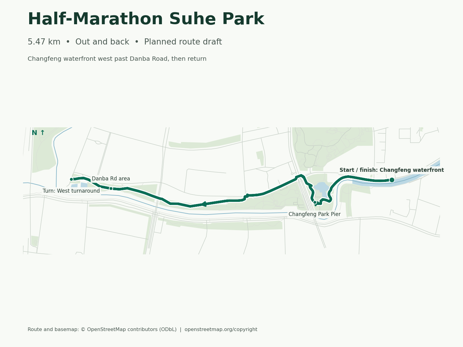
Half-Marathon Suhe Park
Changfeng waterfront → west of Danba Road → same start
- Getting there
- Take Line 15 to Changfeng Park and use Exit 2 for park access. Walk along the river to the start shown on the map.
- Underfoot
- Follow the paved north-bank path west. Turn beyond Danba Road and return along the same waterfront. Allow for short ramps or steps near the pier.
Before you runWater, toilets, bag storage and timing
- Water, toilets and bags
- Runner notes point to lockers under Gubei Road Bridge and near the west entrance of Changfeng No. 1 Green Space. Bring water until the taps and toilets at Danba Road Pier are verified.
- When to go
- Try the turnaround in daylight first. Lighting improvements cover parts of this corridor, with coverage near the turnaround still unchecked.
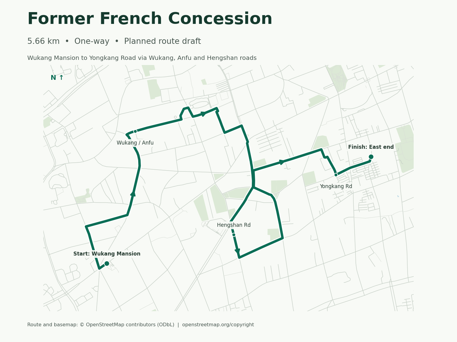
French Concession Streets
Wukang Mansion → Wukang Road → Anfu Road → Hengshan Road → Yongkang Road
- Getting there
- Use Jiaotong University station, Exit 7, for Wukang Mansion. South Shaanxi Road is an option after the finish.
- Underfoot
- Stick to sidewalks where the GPX follows the street centerline. Junctions and narrow pavements break up the rhythm, so save speed work for another route.
Before you runWater, toilets, bag storage and timing
- Water, toilets and bags
- Carry water and keep your bag with you. The Wukang Road visitor center is a restroom option when open.
- When to go
- Start after daylight and before the weekday rush. Shops may still be closed, and side streets under the trees can be darker.
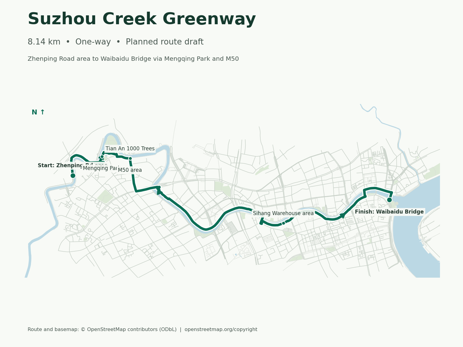
Suzhou Creek Greenway
Near Zhenping Road → Mengqing Park → M50 → Waibaidu Bridge
- Getting there
- Use Zhenping Road station, Exit 6, toward Guangfu West Road. Finish at the south end of Waibaidu Bridge.
- Underfoot
- Expect waterfront paving, short street connections and occasional ramps or steps. Pay attention to the connections near Mengqing Park and M50.
At the south end of Waibaidu Bridge, turn south to continue along the Bund.
Before you runWater, toilets, bag storage and timing
- Water, toilets and bags
- Carry water. Suhewan MixC is an option during business hours and Huangpu Park has toilets near the finish.
- When to go
- Run it in daylight the first time. The path briefly leaves the river, and lighting has only been documented on parts of the route.
Luwan Stadium
- Getting there
- Jiashan Road station, Lines 9 and 12, is the nearest metro option in the runner notes. A runner reports using Gate 2 for the track. Check the venue’s posted public entrance and session hours before going.
- Bag storage
- The running club uses a corner of the track for group sessions. Lockable storage for individual visitors is unconfirmed.
When to Run in Shanghai
Best Months
October-November, March-April
Summer
Hot and humid (30-38°C), run before 7 AM
Winter
Cool and damp (2-10°C), good for training
Rainy Season
June-July (plum rain season)
Major Races in Shanghai
- Shanghai Marathon (November-December)
- Shanghai Half Marathon
- Suzhou Creek Half Marathon (March)
- Shanghai 10K Series
2026 Shanghai Marathon - Dec 6 Countdown
Live countdown timer with weather updates and training motivation for the 2026 Shanghai Marathon - Dec 6.
View Countdown →Want course details and race day strategy? →
Find more races with our Marathon FinderRunning Tips for Shanghai
- Check the local AQI, then enter the reading in the AQI Running Calculator
- Download Amap or Baidu Maps — Google Maps has limited functionality in China
- Carry water or plan a stop at a convenience store. On Xuhui Riverside, there’s a public drinking-water point at the riverside skate plaza
- In summer, start before the day heats up. In winter, check the temperature and air quality
- Check the Luwan Running Club’s latest training notice for the meeting point, start time and sign-up steps
- For evening runs, stick to well-lit stretches and wear something reflective on city streets
Frequently Asked Questions
Do I need to pay to run at Century Park?
No. The 4.94 km Century Park outer loop follows public paths around the perimeter, so you can run it without entering the park.
What AQI level is too high for running in Shanghai?
Practical thresholds: AQI below 50 — run freely; 50-100 — normal training, avoid hard intervals; 100-150 — reduce intensity and duration; above 150 — move indoors or rest. Shanghai's air quality fluctuates most from December to February. Always check real-time conditions before heading out with our AQI Running Calculator.
How do I join a running club in Shanghai?
The Luwan Running Club welcomes runners at its group training sessions. Check the club’s latest notice for the meeting point, time and any sign-up steps before you go.
Where can I do speed work in Shanghai?
For tempo runs, try the 4.94 km Century Park outer loop. For longer intervals, the Xuhui Riverside route covers 4.46 km one way from Lupu Bridge to near Longyao Road Tunnel, or about 8.92 km out and back. For track intervals, see Luwan Stadium and check the venue’s public session hours.
Can I run in Shanghai during summer?
Start before the day heats up, choose a shaded route, and carry water. Check local conditions before leaving and shorten the run or move indoors if conditions are poor.
Useful Tools for Running in Shanghai
Running Weather Score Calculator
Is today good for running? Score any weather 1-100 based on temperature, humidity, wind, and rain. G...
Use Calculator →What to Wear Running by Temperature — Clothing Guide
Enter temperature, wind, and rain to get specific clothing picks for head, torso, legs, hands, and f...
Use Calculator →Race Packing List Generator — Don't Forget Anything
Afraid of forgetting something on race day? Generate a personalized packing checklist for 5K to ultr...
Use Calculator →AQI Running Advisor — Air Quality Calculator
Is it safe to run outside right now? Enter your AQI to get EPA/WHO-based safety ratings, max exercis...
Use Calculator →Dew Point Running Calculator — Pace Adjustment Chart
Enter temperature and humidity to calculate dew point and its impact on your running pace. 7-zone ch...
Use Calculator →Running Shoe Finder — 155 Models from 15 Brands, No Reviews
Free running shoe finder quiz. Answer 6 questions, get 3 spec-matched picks from 15 brands (155 SKUs...
Use Calculator →More Marathon Guides
More City Running Guides
Tokyo, Japan
Where should you run in Tokyo? Explore the iconic Imperial Palace 5K loop, running stations with sho...
Read Guide →Berlin, Germany
Tiergarten loops, Tempelhof runway laps, Grunewald trails, and canal paths in the fastest marathon c...
Read Guide →London, UK
Hyde Park loops, Thames Path, 60+ parkrun sites, and Battersea Park track. London Marathon ballot ti...
Read Guide →New York, USA
NYC running guide: Central Park 9.7K loop, Hudson Greenway 13mi, NYRR 9+1 path to the marathon, Armo...
Read Guide →Boston, USA
Charles River bridge loops (3.1–17 mi), Heartbreak Hill, Jamaica Pond and the Seaport Harborwalk — B...
Read Guide →Chicago, USA
Six Chicago running routes: the 18.5-mile car-free Lakefront Trail, the elevated 606, and the downto...
Read Guide →